Spot ForeCast

SpotForecast

Location Based Services, Maps, and Digital Earth

Wednesday, July 11, 2007

PlaNYC Team Releases Transportation Technical Report

The PlaNYC team has released the technical report providing the detailed background data for the transportation recommendations made in Mayor Michael Bloomberg's April 22 Long-Term Planning & Sustainability speech. It's a big download -- 25 megabytes and 166 pages -- but if you are a New York City transportation policy wonk, it's totally worth it.

The report provides a comprehensive rundown, in one place, of all of the various transportation initiatives that are currently planned, underway or being discussed for New York City. Those who have been following the work of independent consultant Bruce Schaller will recognize some of this material. (Speaking of which: Is Bruce Schaller the Bill James of New York City transportation policy, or what? When is city government going to offer the guy a job?)

The report contains some really interesting maps and charts, like the one above, graphically depicting where Manhattan-bound car commuters come from. The map is broken down by census tract. Height represents the total number of single-passenger drivers and color represents the percentage of commuters who chose to drive alone to workplaces below 96th Street. A darker color means a higher percentage of single-passenger drivers and a lighter color means more people used transit, walked, carpooled or used a ferry or bike. It turns out that only 4.6% of New York City residents drive to work in the Manhattan core in single-passenger motor vehicle.

Here's another great factoid from the report: If New Yorkers owned cars at the same rate as the rest of the nation, it would take 11,000 acres, or all of Manhattan below 136th Street, just to park them end to end.


Sunday, July 08, 2007

Car parking from your cell phone


SpotForeCast car parking is a car parking solution that enables drivers to find available parking spots on demand from any wireless device. There aren’t too many options of parking in the city, but SpotForeCast car parking is the first and only car parking service of it’s kind. SpotForeCast car parking’s matching system makes finding parking more affordable, environmentally friendly, and saves you time.

Monday, June 04, 2007

O'reilly


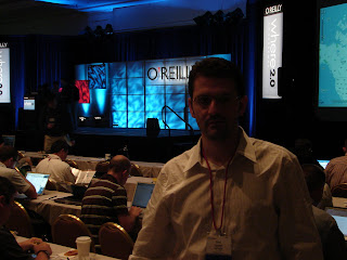
O'reilly, originally uploaded by spotforecast.

SpotForeCast Participation at Where2.0 conference 2007, Google developers day 2007, and Where Yahoo camp in Pictures

Tuesday, May 29, 2007

Garmin launches garmin developer @ Where2.0 2007 conference

Garmin announce www.garmindeveloper.com, Garmin Communicator plugin, and Garmin web services API at the where2007 conference.
Accoriung to Garmin website:
"...a developer zone dedicated to software developers and content providers who want to make their website, applications and data content compatible with Garmin navigation systems. Gain access to free and licensed Garmin resources and a library of Application Programming Interfaces (APIs)."

Garmin toolkits and web services broken into 4 main categories:
Device Communications, Web Services, Smartphone/PDA Services, and Location Based Services.

The Ignite @ Where2.0 in San Jose, CA

Monday 28th 6:30 PM - 9:00 PM @ Where2.0 Fairmont San Jose, Ca

It was the Ignite Where evening when I arrived to San Jose on the 28th. There were 16 talks each lasting only 5 minutes held at the San Jose Fairmont Hotel and moderated by Brady Forest, O'reilly . The audience voted on the best talks with Mozes and two talks did make it to the mainstage during the Where2.0 conference .
"Emad at the Where2.0 Conference May, 28th"

Some of the presentations were:

1. FatDoor is a neighborhood-based community social network. It aims to help you to know more about your neighbors.
2. GeoCommons is a community that enables the collective creation of intelligent maps. With access to a huge new world of geographic data and infinite ways to combine it, GeoCommons empowers you with the tools to gain and share insight across your neighborhood or across the globe.
3. Dopplr is a calendar and location focused social network. It helps you answer the question: "Who do I know in *this* city right now?. Dopplr is currently a private beta.
4. Swivel is a place for exploring data and share your insights with others. Swivel has data about politics, economics, weather, sports, business and more. Swivel explore, compare, share and upload data

5. NationalGeographic Meta Lens is the premier geospatial solution for geo-referencing, management, retrieval, and real-time delivery of digital media.
6. Hipoqih.com, presented by Diego Fernández Domínguez from Spain - is a service composed of a Web and plugin for mobile devices that allow recording warnings and URL associated to any geopoint in the planet. These warnings can be show automatically in terminals with the plugin when approaching that geopoint.
7. Friends of the Urban Forest OSGEO Presented by Amber Bieg, San Francisco. Friends of the Urban Forest, a non-profit tree group dives into osgeo and the difference it makes mapping trees.

Ignite Talks

Tagzania, presented by Luistxo Fernandez. Tagzania is a mashup tagging world locations. Tagzania is a social mapping application, very tied to tagging, folksonomy. If Europe is some sort of periphery as seen from the SF Bay area, we're in the periphery of the periphery, a small Basque company pushing a global website, from somewhere in Northern Spain. But geography is not constrained to a central point, specially since there's Internet, and this European and 'fringe' viewpoint might be interesting: Europe's multilingual, multi-national, full of governments not very friendly with the idea of opening public cartography...Slideshow available at SlideShow

Twittervision presented by David Troy, Popvox. Twittervision visualize traffic on the emerging service Twitter. It intbegrate blogging, location-based services, and text messaging. Twitter and Twittervision provide rich presence of location based services. Twittervision just recently launched it's API, this is a great opportunites for mobile location based services.

Upnext is a 3D virtual cityscape where users can explore and discover their city. UpNext empowers users to search visually, straight from their web browser, to find out what's down the block, in the neighborhood, or all the way across town. We bring the immersive and explorative qualities of virtual worlds to local search.

Live From Where2.0


Google and Google earth just announced that they will launch Google street view today to coincide with all the other launches at Where 2.0 conference 2007. The feature will be available in busy cities like (eg in New York and San Jose).
Check it out
Check it now

Sunday, May 27, 2007

At the Mobile location based services

I just came back from Telematics mobile location based services in Novi, MI. It's been a busy day of discussions and a great opportunity to learn and netwrok. I heard interesting topics and met key players in the industry. It was a must to attend event.

The agenda included a keynote by Symbian VP for US Operations Jerry Panagrossi, a presentation about accuracy vs. simplicity: Critical factors for delivering Quality of Service by Trueposition VP, Business development, Joseph Khori, a presentation about overcome limitations posed by legal issues and regulations by mark Jacobstien, EVP Business Development, Loopt. Followed by panels of discussions about Providing user centric mobile navigation, Monetizing Local Content for the mobile marketplace, Mobile search + location = Fulfilled user expectations?, Profit from proximity based marketing and advertising, Social networking to build mobile communities, and closed by a discussion about Location Enabling the Consumer. The panel were from: Motorola, Cingular, Telematics, Peterson mobility, Soliel group, Trffic.com. Loopt, Skyhook wireless, Jumptap, Infospace, technocom Corporation, Profillium, LBS Globe, Enpocket, Medio, knowledge where, Autodesk, ulocate, Useful networks, IDC, Handmark, Customwetaher, Gearworks, and more.

I had the opportunity talking to experts in the industry about SpotForecast and get some feedback and potential partnerships. They were interested in working together with SpotForecast and how they recognize the problem of car parking. We discussed the challenges behind delivering location and time sensitive information and how this has been for long time the challenging factor for LBS in the navigation devices. Some argued that a solution is being taking too long to be created, others expressed that the availability of such an accuracy is been developing and we might see something soon which will open doors of solutions to businesses and customers.

Location based services, or Location enhanced services are one of the most intersting topics ranking high in businesses and customers interests with the biggest markets in US, EU, Japan and Korea.

There is a future for the communication between cars and smart phones and between consumers and locations. Moreover, Nokia will introduce a Point and find device now being under lab test were you can take a picture from your navigation nokia phone and instantly will receive information about the picture.

Finally, Robb Duffied/ Autodesk LBS introduced how Autodesk is developing LBS using Urban data instead of geodata or zip codes. This got my attention and will need another post to discuss so I will talk about it later.

I have to get ready now to attand the Where2.0 conference in San Jose, Ca. It will be another great extravaganza event.

Saturday, May 12, 2007

Meetings and Networking

I was recently participating in meetings based in NY. Below are some of these meetings:

NY Tech Meetup - Organized by Scott Heiferman CEO/Co-Founder of meetup.com. Last week 5 startups presented there work: What payed most to my attention were: Hitchsters, and HouseParty.

New York Dot Com Hatchery - Organized by YAO-HUI HUANG, CEO of Gigapixelcreative. The HATCHERY is the next level to an incubator. Looking for ideas and businesses to Hatch, making them grow and succeed. And they have the team to guide the process along. It's an opportunity to present and hear a feedback from experts. Some ideas were in the startups, some were just on paper. This was one of the best meetups with a selected panel of experts.

Web2paradigms at Cooper Union/ Students at the Cooper Union for the advancement of Science and Art, NY presented there projects from the class instructed by Sanford Dickert.
Below is the list of the students team products, and a short description of them. :
Course Advisora web interface for the Engineering School course catalogue providing students with the ability to register for classes, remark and print out their schedule for submission to the Registrar.
GeoCart a shopping assistance site to help urban dwellers optimize purchasing products on major auction sites with regard to price and physical location.
SudoView a video interviewing service, allowing recruiters to send out and receive video submissions from candidates - all from their home computers.
ForkOut helping online video producers generate exposure by providing a one-stop site for distribution of videos to major video sites.
Red Hen a community-based chemical spectral service providing incentives for action to drive user submissions and involvement.
To read more about the event and the program go to web2paradigms/

And to subscribe to the Meetups go to www.meetup.com

Hope to see you there

Tuesday, May 01, 2007

What is SpotForeCast?

Finding Parking Spots Never Been Easier.
SpotForeCast™ Web site is under construction
Subscribe now to hear from us.

SpotForeCast™ is a car parking solution that enables the drivers to find parking spots on demand.
SpotForeCast™ is great and simple to use.
SpotForeCast™ will significantly reduce the time spent to find parking spots.
SpotForeCast™ will reply to your request immediately with the available parking spot. SpotForeCast™ will provide easily replaceable solution for all available parking spots.
None of the other parking solutions will address the issues SpotForeCast™ covers, neither are they effective.
SpotForeCast™ simplified the search for potential empty parking spots.
SpotForeCast™ provide green parking solution for healthy commute reducing the amount drivers circulates the blocks trying to find a parking spot.
SpotForeCast™ serve all kinds of parking solutions: garage, public parking, alternative street side parking, metered parking, private parking or any.
SpotForeCast™ is developing a unique solution...Forecasting the available parking spots and casting it to SpotForeCast network of drivers ahead of time. Building a network of commuters who are aware of saving time, saving money, and most important saving the environment, with less frustration and less delays.

Pre-register now and send us an e-mail to: preregister@spotforecast.com to Join our network

It's FREE

We need to first build up our network, as the netwrok grow you will be able to find more options, and we will be able to serve you better.

The SpotForeCast Team

Sunday, April 29, 2007

Share my Car Ride Share my Gas

SpotForeCast™ posted a Campaign at it's FACEBOOK group

Share My Car Ride Share my Gas

About the Campagin:

When you travel, go to and from school or work, etc. post your travel information at Facebook and find your Match to share your ride and reduce GAS cost.

READ how it works:

Now join the group and be part of the campaign. It’s FREE and saves you money and time, it’s environment friendly cutting the time drivers consume gas, and it’s FUN…you can share and discuss your experience. Your friends will know where and when you commut and maybe they will join you. This is a consumer awareness campaign and we “CONSUMERS” can make a difference by networking with each other.

We can live by sharing. Can’t we!!! lets try. Lets change the Corporate mentality of this world...lets save the world.

THIS CAN REALLY WORK.